ALAMATTI BACK -WATER CURVE AT 524.25 METERS
Prof.T.Shivaji Rao, Director,Center for environmental studies, Gitam University, Visakhapatnam | Prof.M.Ramesh, Head of the Department of Civil Engineering, Gitam University,Visakhapatnam, KARNATAKA WANTS MORE WATER TO RAISE ALAMATTI DAM TO 528.3 M. |
To understand basics of backwater curves caused by dams see the following websites:
http://evidence.environment-agency.gov.uk/FCERM/en/FluvialDesignGuide/Chapter7.aspx?pagenum=4 http://bhujangam.blogspot.com/2011/02/back-water-afflux-theory.html
Satara,sangli and Kolhapur Districts are bound to get devastated by extreme floods due to increased height of Alamatti Dam. Why?
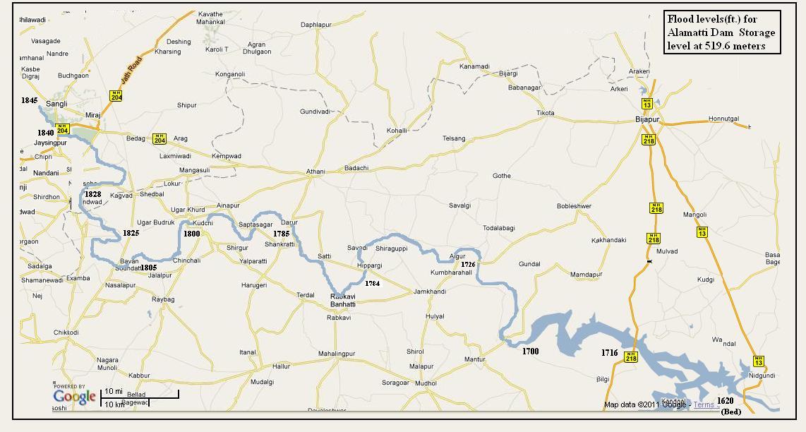
According to the presentations made by Maharashtra Government before the Brijesh Kumar Tribunal Back water affects were considered from the angle of sedimentation and hence the impacts were considered negligible and the tribunal was not furnished with the Scientific Data on Back Water Levels caused by karnataka putting a huge obstructionof a bout a 100 ft.wall in the natural flood flow path of krishna river in the form of Alamatti Dam which is going to be increased by more than 16 to 30 feet in the next one to two yerrs even though the floods of August 2005 caused serious losses to sangli region due to the Alamatti Dam as can be proved by presenting the Back water Levels caused by Alamatti dam as shown the table below.
http://www.hindu.com/2011/02/21/stories/2011022161870600.htm
http://www.hindu.com/2005/09/04/stories/2005090404600400.htm
Karnataka wants to store175 TMC at Alamatti dam along with another 38TMC at Narayanpur,totalling 213 TMC so that utilisation of krishna water can be raised to 320 TMC from Upper Krishna project only.
kARNATAKA WANTS TO GO TO SUPREME cOURT TO RAISE DAM HEIGHT TO 528.8 Meters
see web site: http://www.indiaenvironmentportal.org.in/node/3489?quicktabs_2=1
http://findarticles.com/p/news-articles/dna-daily-news-analysis-mumbai/mi_8111/is_20110101/decision-almatti-dams-height-raises/ai_n56583279/#comments [DNA paper on about 300 villages on river banks]
Irrigation experts also point out that a joint survey by engineers from both States, which was later cleared by the Central Water Commission (CWC), stated that villages upstream up to and beyond Sangli would not be flooded even when the water level at the Almatti dam reached 524.256 m.
.See the following article on "DEVASTATION AND DISPUTE" in FRONTLINE MAGAZINE,Chennai
Satara,sangli and Kolhapur Districts are bound to get devastated by extreme floods due to increased height of Alamatti Dam. Why?
According to the presentations made by Maharashtra Government before the Brijesh Kumar Tribunal Back water affects were considered from the angle of sedimentation and hence the impacts were considered negligible and the tribunal was not furnished with the Scientific Data on Back Water Levels caused by karnataka putting a huge obstructionof a bout a 100 ft.wall in the natural flood flow path of krishna river in the form of Alamatti Dam which is going to be increased by more than 16 to 30 feet in the next one to two yerrs even though the floods of August 2005 caused serious losses to sangli region due to the Alamatti Dam as can be proved by presenting the Back water Levels caused by Alamatti dam as shown the table below.
http://www.hindu.com/2011/02/21/stories/2011022161870600.htm
http://www.hindu.com/2005/09/04/stories/2005090404600400.htm
Karnataka wants to store175 TMC at Alamatti dam along with another 38TMC at Narayanpur,totalling 213 TMC so that utilisation of krishna water can be raised to 320 TMC from Upper Krishna project only.
kARNATAKA WANTS TO GO TO SUPREME cOURT TO RAISE DAM HEIGHT TO 528.8 Meters
see web site: http://www.indiaenvironmentportal.org.in/node/3489?quicktabs_2=1
http://findarticles.com/p/news-articles/dna-daily-news-analysis-mumbai/mi_8111/is_20110101/decision-almatti-dams-height-raises/ai_n56583279/#comments [DNA paper on about 300 villages on river banks]
Irrigation experts also point out that a joint survey by engineers from both States, which was later cleared by the Central Water Commission (CWC), stated that villages upstream up to and beyond Sangli would not be flooded even when the water level at the Almatti dam reached 524.256 m.
.See the following article on "DEVASTATION AND DISPUTE" in FRONTLINE MAGAZINE,Chennai
Maharashtra Officials,Engineers and Advocates were presented with Tabulated Data on the Back Water Levels calculated by Andhra Pradesh for Orissa and Madhya pradesh [Now,Chattisgarh]border areas to estimate the submersion levels at KONTA /MOTU and submitted to the Bachawat Tribunal in 1979 and they were discussed by all the states including the Government of India.As per paragraph 105 of the Bachawat Tribunal Report,With the Polavaram Dam FRL at 150 feet,the rise in back water afflux was estimated at KONTA,about 100km.upstream was estimated to rise by about 20 feet for a peak flood of 30lakhs cusecs and by about 25 feet at a peak flood of 36 lakhs cusecs.and it was later expected to rise by more than 30 feet due to peak flood of 50 lakhs cusecs unilaterally changed by CWC in September,2006.
With this experience at Polavaram and other Dams,Maharashtra should have presented Scientific Data on Back water calculations for an increase of about 25 to 30 meters at Sangli due to different heights of Alamatti Dam from 519.6 m to 524.26 m instead of misleading the Krishna Water Tribunal to take wrong decisions. even when the Tribunal specifically Questioned Maharashtra to give evidence to to prove the injury to Maharashtra by increasing the height of Alamatti dam to 524.26 meters.Maharashtra presented confusing arguments by asking for restraining Alamatti height to512.2m.on page 610 and to 518 m on page 609 of the Tribunal Report for the reason that additional height will cause inundation of Maharashtra territory since the ground level at the border between karnataka and Maharashtra is at 518 meters above the mean sea level.
Such confusing arguments before the Tribunal by Maharashtra created a poor impression with the result that the interests of the farmers and other people of west Maharashtra were sacrificed by the State Government
Catchment Area at Alamatti : 35,300 Sq.km
Catchment Area at Narayanpur : 47,850 Sq.km
, Maximum Flood Discharge : 31,007 Cubic meters per second
.The Type of Dam is a Composite Masonry Dam:
Earthen Dam,with Length of the Dam 405 meters
Spill way,486.5 meters
Power Dam section :156 meters
Moreover the intellectuals ,social activists and politicians and mass media of and NGO organisations are not following the foot steps of the Great patriots like B.G.Tilak who worked for public welfare G.K.Gokhle whobelieved in human dignity and believed in serving the Society,by serving the cause of the poor.
The Peo[ple of Maharashtra must demand for a public hearing in western Maharashtra region on the Environmental Impact Reports[EIA] prepared for sanction of environmental clearence for the Existing Alamatti Dam as its construction will affect the people and their properties by causing submersion of their lands in Sangli and Kolhapur districts.Perhaps without such a public hearing conducted in Maharashtra on Alamatti Dam, if the Union ministry of Environment and Forests gave erroneously such clearence to Alamatti Dam it should be got revoked by questioning it in the High Court as was done by the people of Orissa in filing a public interest litigation[PIL] Case against Polavaram Dam in Orissa High Court in March 2006 when the Court ordered that by construction of Polavaram Dam no lands in orissa should be allowed to be sumerged and no displacement of people.Technical Data.
The Technical data from the Rapid Environmental Impact assessment [EIA] Report on Alamatti Dam power house .Catchment Area at Alamatti : 35,300 Sq.km
Catchment Area at Narayanpur : 47,850 Sq.km
, Maximum Flood Discharge : 31,007 Cubic meters per second
.The Type of Dam is a Composite Masonry Dam:
Earthen Dam,with Length of the Dam 405 meters
Spill way,486.5 meters
Power Dam section :156 meters
Moreover the intellectuals ,social activists and politicians and mass media of and NGO organisations are not following the foot steps of the Great patriots like B.G.Tilak who worked for public welfare G.K.Gokhle whobelieved in human dignity and believed in serving the Society,by serving the cause of the poor.
If Maharashtra Non-Governmental Organisations and social activists are not alert and coming forward ifor taking up such serious public causes,the innocent people of west Maharashtra are bound to suffer as they did in 2005.
WHY KARNATAKA STATE IS HELPLESS IN PREVENTING FLOODING OF SANGLI AND KOLHAPUR DISTRICTS ?
Irrigation experts told Frontline that both States, especially Maharashtra (by virtue of being the upper riparian), probably stored waters in their dams far in excess of the necessary storage level before the onset of the monsoon. They probably did not wait to build up storage levels slowly as the monsoon progressed fearing the level would come down if the monsoon failed. But with excess rains in the catchment areas in Maharashtra, the States were forced to release water from their dams, which had reached their full reservoir levels (FRLs) thereby aggravating the flood situation.
Even as the people are reeling under the impact of the floods, Maharashtra and Karnataka indulged in a dispute over the release of the Krishna waters. Maharashtra has accused Karnataka of not fulfilling its obligation to release adequate quantities of the Krishna waters from the Almatti dam so that the flood situation and the backwater effect in its inundated southern districts could be brought under control. It even got Prime Minister Manmohan Singh to intervene in the matter.
Karnataka has refused to release 6 lakh cusecs of water from the Almatti dam that Maharashtra has been demanding. On August 5, Karnataka released 4.20 lakh cu against an inflow of 3.57 lakh cu, reducing the water level in the dam to 516.4 metres, as against the FRL of 519.6 m.
Karnataka Chief Minster N. Dharam Singh said the release of 6 lakh cu would inundate 600 villages in Karnataka. But with Maharashtra increasing the outflow from its upstream Koyna dam (3.96 lakh cu was released on August 6) steadily, Karnataka, according to engineers at the Almatti dam site, will also have to increase gradually the outflow to 5 lakh cu. The water discharges from the Almatti dam have already affected over 60 villages in Hungund and Muddebihal taluks of Bagalkot and Bijapur districts.
According to the Water Resources Minister M. Mallikarjun Kharge, Maharashtra was needlessly creating a controversy over the discharge of water from Almatti. His contention is that the villages in Sangli and Kolhapur could not have been affected by the backwaters of the Almatti as they are located at a height of 538 metres above sea level. After all, floods had ravaged villages in both districts in 1964 and 1976, before the dam was constructed.He also claimed that in 2002-03 and 2004, when the dam had reached full storage level, no village in Maharashtra was submerged.
HOW EXPERTS OF CWC AND STATES WITHOUT WORKING GIVE WRONG OPINIONS ?
HOW EXPERTS OF CWC AND STATES WITHOUT WORKING GIVE WRONG OPINIONS ?
Irrigation experts also point out that a joint survey by engineers from both States, which was later cleared by the Central Water Commission (CWC), stated that villages upstream up to and beyond Sangli would not be flooded even when the water level at the Almatti dam reached 524.256 m.
see web site:
REPLIES TO MISLEADING STATEMENT OF KARNATAKA MINISTER ON THE SUBMERSION OF LANDS IN MAHARASHTRA DUE TO MAN MADE OBSTRUCTION OF ALAMATTI DAM THAT CHOKES THE NATURAL FLOOD PATH OF THE RIVER:
If Karnataka Minister Kharge is misleading the public on submersion of Sangli during 2005 due to floods in Maharahsra,it is because he is blind to the facts that pre-Alamatti dam moderate floods were unavoidable natural floods while post Alamatti dam abnormal floods that aggravated the damaging potential with increased height were caused by the back water afflux due to man-made introduction of a huge 30m high Alamatti dam which seriously obstructed the natural flow regime of the Krishna river.
http://www.hindu.com/2011/02/21/stories/2011022161870600.htm
The science and Technology oriented Chief Minister of Maharashtra Sri.Prithviraj Chavan has rightly expressed concern that the increased height of Alamatti dam will cause flooding of more villages in Sangli and Kolhapur districts and hence Karnataka must plan to utilize the Krishna water more scientifically and that means by the uses of safer alternative irrigation projects like small dams and barrages instead of storing such enormous quantity of water in a huge reservoir behind the Alamatti dam which is a potential source of great hazard to lakhs of people living downstream of the dam. If after completion of Alamatti dam upto 519.6m height if the upstream Maharashtra villages did not get flooded it must have been due to failure of monsoon rainfall or because of discharge of more water through the spillway gates of Alamatti dam. But if the monsoon is very active and prolonged depressions occurred as in October 2009 when all the reservoirs are full and its tributaries are running to full capacity the additional floods caused by torrential rains of prolonged duration the consequential floods will face a huge obstruction in the form of a 35 to 40m high Alamatti dam placed by man in the natural flow regime of the river which causes a massive increase in the build up of water above natural flood level and that will cause abnormal submersion of villages, towns and cities and fertile agriculture fields all along the river and only in Karnataka but also in Kolhapur, Sangli and Satara districts of Maharashtra. Such man made inundation causes frequent economic losses worth several thousands of crores of rupees and if such losses are considered in making cost benefit analysis the project for raising the height of Alamatti dam automatically becomes economically unviable, ecologically destructive and socially unacceptable for all the people of the Krishna river basin in Karnataka and Maharashtra. That is why urgent action must be taken to get the environmental Impact Assessment studies made for the expansion project of Alamatti reservoir by increasing the height of the dam as contemplated by Karnataka state for irrigation and hydro power generation. These scientific and technical studies made by the irrigation experts and environmental experts of GITAM University are presented here for the information of the general public, concerned NGO’s, the engineering experts, the officials and Ministers of the states and Central Government including the Brijesh Kumar Tribunal on Krishna Water Dispute.
NARMADA WATER DISPUTES TRIBUNAL AWARD SPECIFIED THAT BACKWATER LEVELS TO BE CALCULATED BY CWC BASED ON MWL AND NOT FRL OF RESERVOIR
Back Water calculations based on NARMADA TRIBUNAL Award
Clause XI – Directions on Submergence, Land Acquisition and Displaced Persons.
Sub - Clause I - Definitions
I (1) : "Land" The expression "land" shall have the same meaning as defined in the Land Acquisition Act,
1894 (thereinafter referred to as the Act) which states "the expression 'land' includes benefits to arise out
of land, and things attached to the earth or permanently fastened to anything attached to the earth."
(2) : "Oustee" An 'oustee' shall mean any person who since at least one year prior to the date of
publication of the notification under Section 4 of the Act, has been ordinarily residing or cultivating land or
carrying on any trade, occupation, or calling or working for gain in the area likely to be submerged
permanently or temporarily.
(3) : "Family" (i) A family shall include husband, wife and minor children and other persons dependent on
the head of the family, e.g., widowed mother. (ii) Every major son will be treated as a separate family.
Sub-Clause II - Lands Which are to be Compulsorily Acquired.
II (1) : All land below FRL: Madhya Pradesh and Maharashtra shall acquire for Sardar Sarovar Project under the provisions of the Land Acquisition Act, 1894, all lands of private ownership situated below the FRL + 138.68 m (455') of Sardar Sarovar and all interests therein not belonging to the respective States. If on the basis aforesaid,75 per cent or more land of a contiguous holding of any person is required to be compulsorily acquired, such person shall have the option to compel compulsory acquisition of the entire contiguous holding.
(2) :Buildings and adjoining lands between FRL and above upto backwater effect at MWL: Madhya Pradesh and Maharashtra shall also acquire for Sardar Sarovar Project under the
provisions of the Land Acquisition Act, 1894, all buildings with their appurtenant land situated between
FRL + 138.68 m (455') and MWL + 141.21 m (460') as also those affected by the backwater effect
resulting from MWL + 141.21 m (460').
(3) CWC must calculate backwater levels in consultation with basin states : The backwater level at the highest flood level in Sardar Sarovar shall be worked out by the Central
Water Commission in consultation with Madhya Pradesh and Gujarat.
MAHARASHTRA MUST USE FOLLOWING EXAMPLES ON INCREASED BACKWATER LEVELS IN SANGLI, & KOLHAPUR DISTRICTS DUE TO INCREASED HEIGHT OF ALAMATTI FROM 512.2M AS DEMANDED BY STATE TO 519.6 M BY SUPREME COURT
If Karnataka Minister Kharge is utterly misleading the public on submersion in Maharashtra due to floods caused by Alamatti dam, it is because he is blind to the facts that pre-Alamatti dam floods were unavoidable natural floods while post Alamatti dam floods aggravate the damaging potential of back water afflux due to man-made 30m high Alamatti dam that seriously obstructs the natural flow regime of the Krishna river.
http://www.rtiindia.org/forum/68060-rti-happenings-no-guidelines-studying-backwater-impact-dams-cwc.html [People in 320 villages in the Back water impact area fear flooding during vigorous rainfalls.]
The Science and Technology oriented Chief Minister of Maharashtra Sri.Prithviraj Chavan has rightly expressed concern that the increased height of Alamatti dam will cause flooding of more than 320 villages in Sangli and Kolhapur districts and hence Karnataka must plan to utilize the Krishna water more scientifically and that means by the use of safer alternative irrigation projects like small dams and barrages instead of storing such enormous quantity of water in a huge reservoir behind the Alamatti dam which is a potential hazard, making vulnerable the lives of lakhs of people living downstream of the dam.
With the completion of Alamatti dam upto 519.6m height if the upstream Maharashtra villages did not get flooded it must have been due to failure of monsoon rainfall or because of discharge of adequate water through the spillway gates of Alamatti dam. But if the monsoon is very active and prolonged and depressions were to occur as in October 2009 when all the reservoirs are full and its tributaries are running to full capacity there will be a serious problem. The additional floods caused by torrential rains of prolonged duration will face a huge obstruction in the form of a 35 to 40m high Alamatti dam placed by man in the natural flow regime of the river that causes a massive increase in the build up of water above natural flood level which will cause abnormal submersion of villages, towns and cities and fertile agriculture fields all along the river not only in Karnataka but also in Kolhapur, Sangli and Satara districts of Maharashtra. Such man made inundation causes frequent economic losses worth several thousands of crores of rupees and if such losses are considered in making cost benefit analysis the project for raising the height of Alamatti dam automatically becomes economically unviable, ecologically destructive and socially unacceptable for all the people.
That is why urgent action must be taken to get the Environmental Impact Assessment studies made for the expansion project of Alamatti reservoir by increasing the height as contemplated by Karnataka state for irrigation and hydro power generation. These scientific and technical studies made by the irrigation and environmental experts of GITAM University are presented here for the information of the general public, concerned NGO’s, the engineering experts, the officials and Ministers of the states and Central Government including the Brijesh Kumar Tribunal on Krishna Water Dispute for making a review of the matter.
POLAVARAM BACKWATER AFFLUX - AP STATE GOVERNMENT
Name of the site | Discharge in cusecs | |
30,00,000 | 36,00,000 | |
(i) Without Dam: Polavaram Dam Kunavaram Konta | 92.07 157.37 158.07 | 94.88 (28.92) 165.57 (50.46) 166.10 (50.63) |
(ii) With Dam (and with different pond levels during floods (a) Polavaram dam Kunavaram Konta | 140.00 163.80 164.23 | 140.00 (42.67) 170.09 (51.84) 170.75 (52.04) |
(b) Polavaram dam Kunavaram Konta | 145.00 165.85 166.23 | 145.00 (44.20) 172.03 (52.44) 172.33 (52.53) |
(c) Polavaram dam Kunavaram Konta | 150.00 168.23 168.54 | 150.00 (45.72) 173.97 (53.03) 174.22 (53.10) |
According to para 103 of the Bachawat Tribunal report on Godavari water disputes dt.27-11-1979 the tribunal stated that Andhra Pradesh made necessary flood and backwater calculations for the pre and post project conditions of the Polavaram project a copy of which was sent by AP state by Maharashtra. The computation on backwater levels clearly show that over a distance of 60 to 65km at Kunavaram the backwater levels increased from 157ft. without a dam to 168ft. with the height of the Polavaram Dam fixed at +150ft. above the mean sea level and this clearly shows that at the flood discharge rate of 30 lakh cusecs the backwater levels increased by more than 10ft. if the Polavaram dam is constructed. Thus the Maharashtra state Government Engineers, experts and officials and Andhra Pradesh state Engineers , experts and officials are fully aware of the phenomena and facts about the raise of the backwater levels in the upstream areas of the river due to the placement of an obstruction in the natural flow regime of an open channel or a river like Krishna river. Such calculations should have been made both by Maharashtra and Andhra Pradesh engineers and experts for presentation before the tribunal to prove that such backwater affluxes will cause serious injury to the human and animal populations and the properties of people in the form of crops, buildings and infrastructure facilities.
POLAVARAM PROJECT – BACKWATER PROFILE CALCULATIONS
Name of the site | Discharge in Cumecs | |||
85,000 (30 lakh cusecs) | 1,02,000 (36 lakh cusecs) | 1,36,200 (48 lakh cusecs) | 1,54,300 (54lakh cusecs) | |
i) Without dam | ||||
Polavaram | 28.06m (92.07ft) | 28.92m (94.88ft) | 30.6m (100.48ft) | 31.5m(103.20ft) |
Kunavaram | 47.9 m (157.2 ft) | 50.5m (165.8ft) | 54.57m(179.0ft) | 55.68m(182.7ft) |
Konta | 48.18m(158.1ft) | 50.63m(166.1ft) | ||
Bhadrachalam | 54.23m(177.9ft) | 57.09m(187.3ft) | 61.76m (202.6 ft) | 63.57m(208.6ft) |
ii) With the dam (with different pond levels due to floods) | ||||
a) Polavaram | 42.67m(140ft) | 42.67m(140ft) | 42.67m(140ft) | 42.67m(140ft) |
Kunavaram | 50.39m(165.3ft) | 52.58m(172.5ft) | 56.86m(186.5ft) | 58.95m(193.4ft) |
Bhadrachalam | 55.38m(181.7ft) | 58.04m(190.4ft) | 62.89m(206.3ft) | 65.16m(213.8ft) |
b) Polavaram | 45.72m(150ft) | 45.72m(150ft) | 45.72m(150ft) | 45.72m(150ft) |
Kunavaram | 52.18m (171.2 ft) | 54.18 m(177.8) | 58.22m(191.0ft) | 60.21m(197.5ft) |
Bhadrachalam | 56.40m(185.0ft) | 58.93m (193.3) | 63.64m(208.8ft) | 65.88m(216.1ft) |
Note: The above values are based upon the information from the Bachawat Tribunal Report and the calculations made by the author on the basis of the Advanced Numerical Methods using the Standard-step Method described by K.Subrahmanya in his standard book on flow in open channels.
The computer based backwater calculations made by the authors used the data presented by the AP State Government to the Bachawat Tribunal for peak flood flow of 30 lakhs cusecs and 36 lakh cusecs and the calculations were extended to cover 48 and 54 lakh cusecs peak floods. Consequently the increased backwater levels with and without the Polavaram dam show that when the Polavaram dam reservoir level is kept at 150ft. the backwater levels touching 157ft. at 30 lakhs cusecs discharge rose to 198ft. at Kunavaram over a distance of about 60 to 65km upstream of the Polavaram dam and this clearly indicates that with increased height of Alamatti dam Sangli district located about 250km upstream of Alamatti dam is bound to be frequently drowned by the backwater afflux caused by Alamatti dam resulting in serious threat to lives of lakhs of people and loss of crops in fertile lands in the Western Maharashtra districts amounting to several thousands of crores of worth of properties.
Chinese Example: Backwater afflux due to Three Gorges Dam rose by 13m in cities 200km upstream:
Refer to the findings of the "Experimental Research on the Impact of the 1954 Major Flood on the Chongqing Harbor Reach," which the Institute of Water Conservancy and Hydro-electric Power Research (IWCHPR) released in July, 1988. If the Three Gorges reservoir were required to store flood waters of the magnitude of the 1954 flood and ensure the safety of downstream areas by maintaining a maximum allowable controlled flood discharge at Chenglingji, the water level in the reservoir would increase by six to eight meters in July, and seven to 13 meters in August. This would be a striking increase from normal flood years. The water level at the dam would increase from 145 meters (the flood-control level) to 175 meters, and the backwater level at Chongqing would increase from the normal flood level of 185.3 meters to 198.1 meters, causing a significant increase in sedimentation.It means that the back water levels increased by 13 meters at Chongquing City located about 200 km.upstream of Three Gorges Dam
ALMATTI Back water profile Calculations 28-02-2011 (for n=0.05, 45,000 cumecs, 524.25m stage at Alamatti ,widths varying from 500m (Sangli ) to 1500 m(Alamatti Dam)
1 | 2 | 3 | 4 | 5 | 6 | 7 | 8 | 9 | 10 | 11 | 12 | 13 | 14 |
Station | No. Trail | Elv. BL | depth,m | Elv.stage | Width | Area | Discharge | Velocity | Vel.Head | Total H | R | Sf term1 | Length(M) |
ALMATTI | 0 | 489 | 35.25 | 524.25 | 1500 | 52875 | 45000 | 0.851064 | 0.036917 | 524.2869 | 33.66762 | 5062500 | |
A to NH218-1 | 1 | 491 | 34 | 525 | 1500 | 51000 | 45000 | 0.882353 | 0.039681 | 525.0397 | 32.52551 | 5062500 | 25000 |
A to NH218-2 | 2 | 491 | 33.70164 | 524.7016 | 1500 | 50552.45 | 45000 | 0.890165 | 0.040387 | 524.742 | 32.25236 | 5062500 | 25000 |
NH218 | 3 | 491 | 33.70159 | 524.7016 | 1500 | 50552.39 | 45000 | 0.890166 | 0.040387 | 524.742 | 32.25232 | 5062500 | 25000 |
N to Res Approach | 1 | 494 | 30.74 | 524.74 | 1500 | 46110 | 45000 | 0.975927 | 0.048544 | 524.7885 | 29.52968 | 5062500 | 24000 |
N to Res Approach | 2 | 494 | 31.22982 | 525.2298 | 1500 | 46844.74 | 45000 | 0.96062 | 0.047033 | 525.2769 | 29.98141 | 5062500 | 24000 |
A Res approach | 3 | 494 | 31.23064 | 525.2306 | 1500 | 46845.96 | 45000 | 0.960595 | 0.047031 | 525.2777 | 29.98216 | 5062500 | 24000 |
Res App to Algur | 1 | 498 | 27.27 | 525.27 | 1000 | 27270 | 45000 | 1.650165 | 0.138789 | 525.4088 | 25.85962 | 5062500 | 40000 |
Res App to Algur | 2 | 498 | 28.5408 | 526.5408 | 1000 | 28540.8 | 45000 | 1.57669 | 0.126705 | 526.6675 | 26.99962 | 5062500 | 40000 |
Res App to Algur | 3 | 498 | 30.30966 | 528.3097 | 1000 | 30309.66 | 45000 | 1.484675 | 0.112348 | 528.422 | 28.57732 | 5062500 | 40000 |
Algur | 4 | 498 | 30.35573 | 528.3557 | 1000 | 30355.73 | 45000 | 1.482422 | 0.112007 | 528.4677 | 28.61827 | 5062500 | 40000 |
Al to Hippargi | 1 | 508 | 20.46 | 528.46 | 750 | 15345 | 45000 | 2.932551 | 0.438321 | 528.8983 | 19.40146 | 5062500 | 28000 |
Al to Hippargi | 2 | 508 | 22.43919 | 530.4392 | 750 | 16829.4 | 45000 | 2.673893 | 0.364409 | 530.8036 | 21.17229 | 5062500 | 28000 |
Al to Hippargi | 3 | 508 | 27.4155 | 535.4155 | 750 | 20561.62 | 45000 | 2.188543 | 0.244124 | 535.6596 | 25.54775 | 5062500 | 28000 |
Hippargi | 4 | 508 | 28.30184 | 536.3018 | 750 | 21226.38 | 45000 | 2.120003 | 0.229073 | 536.5309 | 26.31575 | 5062500 | 28000 |
Hi to Halyal | 1 | 513 | 23.53 | 536.53 | 500 | 11765 | 45000 | 3.824904 | 0.745662 | 537.2757 | 21.50587 | 5062500 | 25000 |
Hi to Halyal | 2 | 513 | 25.93306 | 538.9331 | 500 | 12966.53 | 45000 | 3.470473 | 0.613873 | 539.5469 | 23.49579 | 5062500 | 25000 |
Hi to Halyal | 3 | 513 | 32.15623 | 545.1562 | 500 | 16078.12 | 45000 | 2.798835 | 0.39926 | 545.5555 | 28.49151 | 5062500 | 25000 |
Halyal | 4 | 513 | 33.46605 | 546.466 | 500 | 16733.02 | 45000 | 2.689293 | 0.368619 | 546.8347 | 29.51504 | 5062500 | 25000 |
Ha to Kudichi | 1 | 514 | 32.83 | 546.83 | 500 | 16415 | 45000 | 2.741395 | 0.38304 | 547.213 | 29.0192 | 5062500 | 26000 |
Ha to Kudichi | 2 | 514 | 33.03349 | 547.0335 | 500 | 16516.75 | 45000 | 2.724508 | 0.378335 | 547.4118 | 29.17808 | 5062500 | 26000 |
Ha to Kudichi | 3 | 514 | 37.15629 | 551.1563 | 500 | 18578.14 | 45000 | 2.422201 | 0.299035 | 551.4553 | 32.34849 | 5062500 | 26000 |
Kudichi | 4 | 514 | 37.4248 | 551.4248 | 500 | 18712.4 | 45000 | 2.404822 | 0.294759 | 551.7196 | 32.55182 | 5062500 | 26000 |
Ku to Diggerwadi | 1 | 515 | 36.72 | 551.72 | 500 | 18360 | 45000 | 2.45098 | 0.306183 | 552.0262 | 32.0173 | 5062500 | 13000 |
Ku to Diggerwadi | 2 | 515 | 33.96069 | 548.9607 | 500 | 16980.34 | 45000 | 2.650123 | 0.357959 | 549.3186 | 29.89911 | 5062500 | 13000 |
Old Diggerwadi | 3 | 515 | 38.43493 | 553.4349 | 500 | 19217.46 | 45000 | 2.34162 | 0.279469 | 553.7144 | 33.31334 | 5062500 | 13000 |
Odigg to Shaharpur | 1 | 518 | 35.71 | 553.71 | 500 | 17855 | 45000 | 2.520302 | 0.323747 | 554.0337 | 31.24672 | 5062500 | 25000 |
Odigg to Shaharpur | 2 | 518 | 36.78487 | 554.7849 | 500 | 18392.44 | 45000 | 2.446658 | 0.305104 | 555.09 | 32.06661 | 5062500 | 25000 |
Odigg to Shaharpur | 3 | 518 | 39.19482 | 557.1948 | 500 | 19597.41 | 45000 | 2.296222 | 0.268738 | 557.4636 | 33.88271 | 5062500 | 25000 |
Odigg to Shaharpur | 4 | 518 | 39.26811 | 557.2681 | 500 | 19634.05 | 45000 | 2.291936 | 0.267736 | 557.5358 | 33.93747 | 5062500 | 25000 |
Odigg to Shaharpur | 5 | 518 | 40.05663 | 558.0566 | 500 | 20028.32 | 45000 | 2.246819 | 0.257298 | 558.3139 | 34.52484 | 5062500 | 25000 |
Odigg to Shaharpur | 6 | 518 | 41.91382 | 559.9138 | 500 | 20956.91 | 45000 | 2.147263 | 0.235002 | 560.1488 | 35.89571 | 5062500 | 25000 |
Shaharpur | 7 | 518 | 42.6414 | 560.6414 | 500 | 21320.7 | 45000 | 2.110625 | 0.227051 | 560.8685 | 36.42803 | 5062500 | 25000 |
Shr to Narsobawadi | 1 | 520 | 40.86 | 560.86 | 500 | 20430 | 45000 | 2.202643 | 0.24728 | 561.1073 | 35.11999 | 5062500 | 10000 |
Shr to Narsobawadi | 2 | 520 | 38.49415 | 558.4941 | 500 | 19247.07 | 45000 | 2.338018 | 0.27861 | 558.7728 | 33.35782 | 5062500 | 10000 |
Narsobawadi | 3 | 520 | 41.87595 | 561.876 | 500 | 20937.98 | 45000 | 2.149205 | 0.235427 | 562.1114 | 35.86794 | 5062500 | 10000 |
Nar to Ankali | 1 | 525 | 37.11 | 562.11 | 500 | 18555 | 45000 | 2.425222 | 0.299781 | 562.4098 | 32.3134 | 5062500 | 27000 |
Nar to Ankali | 2 | 525 | 38.57211 | 563.5721 | 500 | 19286.06 | 45000 | 2.333292 | 0.277485 | 563.8496 | 33.41636 | 5062500 | 27000 |
Ankali | 3 | 525 | 40.49566 | 565.4957 | 500 | 20247.83 | 45000 | 2.22246 | 0.25175 | 565.7474 | 34.85048 | 5062500 | 27000 |
Ank to Sangli | 1 | 528 | 37.74 | 565.74 | 500 | 18870 | 45000 | 2.384738 | 0.289856 | 566.0299 | 32.79002 | 5062500 | 10000 |
Ank to Sangli | 2 | 528 | 35.62464 | 563.6246 | 500 | 17812.32 | 45000 | 2.526341 | 0.325301 | 563.9499 | 31.18135 | 5062500 | 10000 |
Sangli | 3 | 528 | 39.02538 | 567.0254 | 500 | 19512.69 | 45000 | 2.306192 | 0.271076 | 567.2965 | 33.75601 | 5062500 | 18000 |
Note: A second analysis for backwater curve was also made by assuming that when massive floods occur for a number of days the flood water over steps the bank and is contained in a larger width than that of the cross section of the river and for this purpose it is assumed that the effect of afflux would create water flow regime with a uniform width of 1500m and the computer aided calculations showed a slight reduction in the stage elevation at Sangli of 546m with the bed level estimated at 528 as per the calculation by standard step method. The following table presents the backwater levels from the different stations from Alamatti dam .
ALMATTI Back water profile Calculations 26-02-2011 (for n=0.05, 31,000 cumecs, 519.6 m stage near Alamatti dam widths 1500 m)
Station | No. Trail | Elv. BL | depth,m | Elv.stage | Width | Area | Discharge | Velocity |
ALMATTI | 0 | 489 | 30.6 | 519.6 | 1500 | 45900 | 31000 | 0.675381 |
A to NH218-1 | 1 | 491 | 30 | 521 | 1500 | 45000 | 31000 | 0.688889 |
A to NH218-2 | 2 | 491 | 29.12262 | 520.1226 | 1500 | 43683.93 | 31000 | 0.709643 |
NH218 | 3 | 491 | 29.12324 | 520.1232 | 1500 | 43684.86 | 31000 | 0.709628 |
N to Res Approach | 1 | 494 | 26.15 | 520.15 | 1500 | 39225 | 31000 | 0.790312 |
N to Res Approach | 2 | 494 | 26.88844 | 520.8884 | 1500 | 40332.66 | 31000 | 0.768608 |
A Res approach | 3 | 494 | 26.89234 | 520.8923 | 1500 | 40338.51 | 31000 | 0.768496 |
Res App to Algur | 1 | 498 | 22.92 | 520.92 | 1500 | 34380 | 31000 | 0.901687 |
Res App to Algur | 2 | 498 | 23.36484 | 521.3648 | 1500 | 35047.26 | 31000 | 0.88452 |
Res App to Algur | 3 | 498 | 24.53144 | 522.5314 | 1500 | 36797.16 | 31000 | 0.842456 |
Algur | 4 | 498 | 24.54817 | 522.5482 | 1500 | 36822.26 | 31000 | 0.841882 |
Al to Hippargi | 1 | 508 | 14.58 | 522.58 | 1500 | 21870 | 31000 | 1.417467 |
Al to Hippargi | 2 | 508 | 15.70304 | 523.703 | 1500 | 23554.55 | 31000 | 1.316094 |
Al to Hippargi | 3 | 508 | 18.46472 | 526.4647 | 1500 | 27697.07 | 31000 | 1.119252 |
Hippargi | 4 | 508 | 18.78958 | 526.7896 | 1500 | 28184.38 | 31000 | 1.0999 |
Hi to Halyal | 1 | 513 | 13.85 | 526.85 | 1500 | 20775 | 31000 | 1.492178 |
Hi to Halyal | 2 | 513 | 14.99951 | 527.9995 | 1500 | 22499.26 | 31000 | 1.377823 |
Hi to Halyal | 3 | 513 | 18.13761 | 531.1376 | 1500 | 27206.42 | 31000 | 1.139437 |
Halyal | 4 | 513 | 18.63579 | 531.6358 | 1500 | 27953.68 | 31000 | 1.108977 |
Ha to Kudichi | 1 | 514 | 17.69 | 531.69 | 1500 | 26535 | 31000 | 1.168268 |
Ha to Kudichi | 2 | 514 | 17.93614 | 531.9361 | 1500 | 26904.2 | 31000 | 1.152236 |
Ha to Kudichi | 3 | 514 | 20.16269 | 534.1627 | 1500 | 30244.03 | 31000 | 1.024996 |
Ha to Kudichi | 4 | 514 | 20.28896 | 534.289 | 1500 | 30433.44 | 31000 | 1.018616 |
Ha to Kudichi | 5 | 514 | 20.43942 | 534.4394 | 1500 | 30659.14 | 31000 | 1.011118 |
Ha to Kudichi | 6 | 514 | 21.93548 | 535.9355 | 1500 | 32903.22 | 31000 | 0.942157 |
Kudichi | 7 | 514 | 22.06403 | 536.064 | 1500 | 33096.05 | 31000 | 0.936668 |
Ku to Diggerwadi | 1 | 515 | 21.1 | 536.1 | 1500 | 31650 | 31000 | 0.979463 |
Ku to Diggerwadi | 2 | 515 | 18.4081 | 533.4081 | 1500 | 27612.15 | 31000 | 1.122694 |
Old Diggerwadi | 3 | 515 | 22.03252 | 537.0325 | 1500 | 33048.79 | 31000 | 0.938007 |
Odigg to Shaharpur | 1 | 518 | 19.07 | 537.07 | 1500 | 28605 | 31000 | 1.083727 |
Odigg to Shaharpur | 2 | 518 | 18.28779 | 536.2878 | 1500 | 27431.68 | 31000 | 1.13008 |
Odigg to Shaharpur | 3 | 518 | 20.82552 | 538.8255 | 1500 | 31238.27 | 31000 | 0.992372 |
Odigg to Shaharpur | 4 | 518 | 20.95507 | 538.9551 | 1500 | 31432.6 | 31000 | 0.986237 |
Odigg to Shaharpur | 5 | 518 | 20.4062 | 538.4062 | 1500 | 30609.3 | 31000 | 1.012764 |
Odigg to Shaharpur | 6 | 518 | 22.24491 | 540.2449 | 1500 | 33367.36 | 31000 | 0.929052 |
Shaharpur | 7 | 518 | 21.95927 | 539.9593 | 1500 | 32938.91 | 31000 | 0.941136 |
Shr to Narsobawadi | 1 | 520 | 20 | 540 | 1500 | 30000 | 31000 | 1.033333 |
Shr to Narsobawadi | 2 | 520 | 20.58238 | 540.5824 | 1500 | 30873.56 | 31000 | 1.004095 |
Narsobawadi | 3 | 520 | 21.00228 | 541.0023 | 1500 | 31503.41 | 31000 | 0.98402 |
Nar to Ankali | 1 | 525 | 16.05 | 541.05 | 1500 | 24075 | 31000 | 1.287643 |
Nar to Ankali | 2 | 525 | 17.57806 | 542.5781 | 1500 | 26367.09 | 31000 | 1.175708 |
Ankali | 3 | 525 | 19.73213 | 544.7321 | 1500 | 29598.19 | 31000 | 1.047361 |
Ank to Sangli | 1 | 528 | 16.78 | 544.78 | 1500 | 25170 | 31000 | 1.231625 |
Ank to Sangli | 2 | 528 | 15.10021 | 543.1002 | 1500 | 22650.32 | 31000 | 1.368634 |
Sangli | 3 | 528 | 18.03571 | 546.0357 | 1500 | 27053.56 | 31000 | 1.145875 |

According to the President of the International Commission on Large Dams, Prof.L.Berga a review of the extreme floods reported on several occassions in large rivers all over the world including the Narmada dam in India the magnitudeof extreme floods has been presented in the form of nomograms and tables and equations have been formulated and published for being used by other countries in the world. India is also a member which declared that the country follows these international ICOLD standards for design of dams See the following websites for the full length article and the nomogram on the subject by Prof.L.Berga.
https://sites.google.com/site/shivajirao32/polavaramdam-1Article by President,ICOLD, See Web: LBergaextremefloods.doc
Based on the International Standards and also ISI Standards the inflow design flood magnitude is estimated for the calculations used for Alamatti Dam Break Analysis and also for calculating the backwater levels.
During September, October 2009 Extreme floods occurred in Krishna river resulting in extensive submersion of lands, villges, towns and cities along the banks of the Krishna river and hence the following graph is very relevant for calculation of peak floods for irrigation design purposes.

http://bhujangam.blogspot.com/2011/03/alamatti-dam-upto-5288-meters-raised-in.html